Cotton Town, Pennsylvania | |
|---|---|
 Cotton Town  Cotton Town | |
| Coordinates: 40°16′46″N 78°28′51″W / 40.27944°N 78.48083°W | |
| Country | United States |
| State | Pennsylvania |
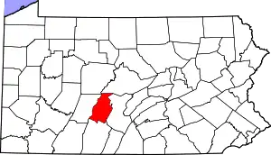
| County | Blair |
| Township | Greenfield |
| Area | |
| • Total | 0.03 sq mi (0.08 km2) |
| • Land | 0.03 sq mi (0.08 km2) |
| • Water | 0.00 sq mi (0.00 km2) |
| Elevation | 1,260 ft (380 m) |
| Population | |
| • Total | 22 |
| • Density | 733.33/sq mi (287.36/km2) |
| Time zone | UTC-5 (Eastern (EST)) |
| • Summer (DST) | UTC-4 (EDT) |
| ZIP Codes | 16625 (Claysburg) |
| Area code(s) | 814/582 |
| FIPS code | 42-16432 |
| GNIS feature ID | 2805479[3] |
Clappertown is an unincorporated community and census-designated place (CDP) in Blair County, Pennsylvania, United States. It was first listed as a CDP prior to the 2020 census.[3]
The CDP is in southern Blair County, in the southeastern part of Greenfield Township. It is in the valley of Smoky Run, at the intersection of Cottontown/Lower Claar Road with Pine Hollow/Schellsburg Road. It is 2 miles (3 km) southwest of Claysburg via Pine Hollow Road. Altoona is 20 miles (32 km) to the north. Smoky Run is a southeastward-flowing tributary of Beaverdam Creek, one of the headwaters of the Frankstown Branch of the Juniata River, part of the Susquehanna River watershed.
Demographics
| Census | Pop. | Note | %± |
|---|---|---|---|
| 2020 | 22 | — | |
| U.S. Decennial Census[4][2] | |||
References
- ↑ "ArcGIS REST Services Directory". United States Census Bureau. Retrieved October 12, 2022.
- 1 2 "Census Population API". United States Census Bureau. Retrieved October 12, 2022.
- 1 2 "Clappertown Census Designated Place". Geographic Names Information System. United States Geological Survey, United States Department of the Interior.
- ↑ "Census of Population and Housing". Census.gov. Retrieved June 4, 2016.
This article is issued from Wikipedia. The text is licensed under Creative Commons - Attribution - Sharealike. Additional terms may apply for the media files.