Montreuil-l'Argillé | |
|---|---|
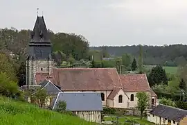 The church in Montreuil-l'Argillé | |
 Coat of arms | |
Location of Montreuil-l'Argillé | |
 Montreuil-l'Argillé 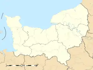 Montreuil-l'Argillé | |
| Coordinates: 48°56′22″N 0°28′53″E / 48.9394°N 0.4814°E | |
| Country | France |
| Region | Normandy |
| Department | Eure |
| Arrondissement | Bernay |
| Canton | Breteuil |
| Government | |
| • Mayor (2020–2026) | Jean-Louis Groult[1] |
| Area 1 | 13.72 km2 (5.30 sq mi) |
| Population | 808 |
| • Density | 59/km2 (150/sq mi) |
| Time zone | UTC+01:00 (CET) |
| • Summer (DST) | UTC+02:00 (CEST) |
| INSEE/Postal code | 27414 /27390 |
| Elevation | 161–225 m (528–738 ft) (avg. 172 m or 564 ft) |
| 1 French Land Register data, which excludes lakes, ponds, glaciers > 1 km2 (0.386 sq mi or 247 acres) and river estuaries. | |
Montreuil-l'Argillé (French pronunciation: [mɔ̃tʁœj laʁʒije]) is a commune in the Eure department in Normandy in northern France.
Population
| Year | Pop. | ±% |
|---|---|---|
| 1962 | 736 | — |
| 1968 | 755 | +2.6% |
| 1975 | 773 | +2.4% |
| 1982 | 726 | −6.1% |
| 1990 | 706 | −2.8% |
| 1999 | 740 | +4.8% |
| 2008 | 786 | +6.2% |
See also
References
- ↑ "Répertoire national des élus: les maires". data.gouv.fr, Plateforme ouverte des données publiques françaises (in French). 9 August 2021.
- ↑ "Populations légales 2021". The National Institute of Statistics and Economic Studies. 28 December 2023.
Wikimedia Commons has media related to Montreuil-l'Argillé.
This article is issued from Wikipedia. The text is licensed under Creative Commons - Attribution - Sharealike. Additional terms may apply for the media files.