Fairplay Township Marion County, Kansas | |
|---|---|
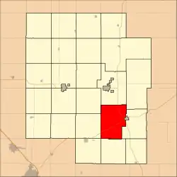 Location within Marion County | |
 Fairplay Township Marion County, Kansas Location within the state of Kansas | |
| Coordinates: 38°14′03″N 96°59′23″W / 38.2340855°N 96.9898118°W[1] | |
| Country | United States |
| State | Kansas |
| County | Marion |
| Area | |
| • Total | 45 sq mi (120 km2) |
| Dimensions | |
| • Length | 8.0 mi (12.9 km) |
| • Width | 6.0 mi (9.7 km) |
| Elevation | 1,371 ft (418 m) |
| Population | |
| • Total | 50 |
| • Density | 1.1/sq mi (0.43/km2) |
| Time zone | UTC-6 (CST) |
| • Summer (DST) | UTC-5 (CDT) |
| Area code | 620 |
| FIPS code | 20-22350 [1] |
| GNIS ID | 477371 [1] |
| Website | County website |
Fairplay Township is a township in Marion County, Kansas, United States.[1] As of the 2010 census, the township population was 107, not including the city of Florence.[2]
Geography
Fairplay Township covers an area of 45 square miles (116.5 km2).
Communities
The township contains the following settlements:
- City of Florence (west part). The east part of Florence is located in Doyle Township.
- Ghost town of Oursler.
Cemeteries
The township contains the following cemeteries:
Transportation
U.S. Route 50 and U.S. Route 77 pass through the township.[4]
References
- 1 2 3 4 5 "Fairplay Township, Marion County, Kansas", Geographic Names Information System, United States Geological Survey, United States Department of the Interior
- 1 2 "2010 Total Population - Township of Fairplay". U.S. Census Bureau. Archived from the original on February 12, 2020. Retrieved November 16, 2013.
- 1 2 Marion County Cemetery List. Archived May 9, 2013, at the Wayback Machine
- ↑ Marion County Highway Map; KSDOT.
Further reading
External links
- Marion County website
- City-Data.com
- Marion County maps: Current, Historic, KDOT
Places adjacent to Fairplay Township, Marion County, Kansas | |
|---|---|
Municipalities and communities of Marion County, Kansas, United States | ||
|---|---|---|
| Cities | 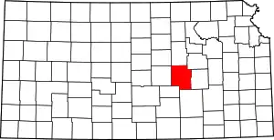 Map of Kansas highlighting Marion County | |
| Unincorporated communities | ||
| Ghost towns | ||
| Townships | ||
| Footnotes | †This community is designated a Census-Designated Place (CDP) by the United States Census Bureau. ‡This community also has portions in an adjacent county or counties. | |
This article is issued from Wikipedia. The text is licensed under Creative Commons - Attribution - Sharealike. Additional terms may apply for the media files.