Cloverdale, Alabama | |
|---|---|
 Cloverdale, Alabama  Cloverdale, Alabama | |
| Coordinates: 33°27′10″N 86°23′08″W / 33.45278°N 86.38556°W | |
| Country | United States |
| State | Alabama |
| County | Shelby |
| Elevation | 446 ft (136 m) |
| Time zone | UTC-6 (Central (CST)) |
| • Summer (DST) | UTC-5 (CDT) |
| Area code(s) | 205, 659 |
| GNIS feature ID | 146394[1] |
Cloverdale is an unincorporated community in Shelby County, Alabama, United States, located along Alabama State Route 53, 5 miles (8.0 km) north-northeast of Vincent.
References
Municipalities and communities of Shelby County, Alabama, United States | ||
|---|---|---|
| Cities | 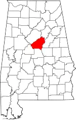 Map of Alabama highlighting Shelby County | |
| Towns | ||
| CDPs | ||
| Other unincorporated communities | ||
| Footnotes | ‡This populated place also has portions in an adjacent county or counties | |
This article is issued from Wikipedia. The text is licensed under Creative Commons - Attribution - Sharealike. Additional terms may apply for the media files.