| Buëch | |
|---|---|
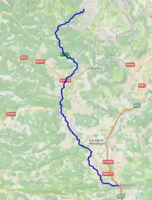
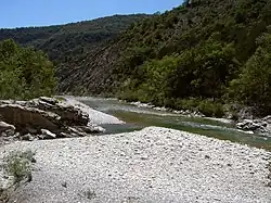 Buëch River | |
 | |
| Location | |
| Country | France |
| Physical characteristics | |
| Source | |
| • location | Dauphiné Alps |
| Mouth | |
• location | Durance |
• coordinates | 44°12′5″N 5°56′35″E / 44.20139°N 5.94306°E |
| Length | 85 km (53 mi) |
| Basin size | 1,478 km2 (571 sq mi) |
| Basin features | |
| Progression | Durance→ Rhône→ Mediterranean Sea |
The Buëch (French pronunciation: [bɥɛʃ][1]), Occitan Bueg (Occitan pronunciation: [bɥetʃ]) is a river in southeastern France, a right tributary of the Durance. It is 85.3 km (53.0 mi) long.[2] Its drainage basin is 1,478 km2 (571 sq mi).[3] Its source is in the Dauphiné Alps, near the peak of Grand Ferrand. It flows generally southward for most of its course in the Hautes-Alpes département, and flows into the Durance at Sisteron.
Départements and towns along the Buëch include:
References
- ↑ "La rivière Buëch - YouTube". www.youtube.com. Retrieved 2021-02-03.
- ↑ Sandre. "Fiche cours d'eau - Le Buëch (X10-0400)".
- ↑ Bassin versant : Buëch (Le), Observatoire Régional Eau et Milieux Aquatiques en PACA
Wikimedia Commons has media related to Buëch.
This article is issued from Wikipedia. The text is licensed under Creative Commons - Attribution - Sharealike. Additional terms may apply for the media files.